UAV Data as Alternative to Field Sampling to Map Woody Invasive Species Based on Combined Sentinel-1 and Sentinel-2 Data
Abstract
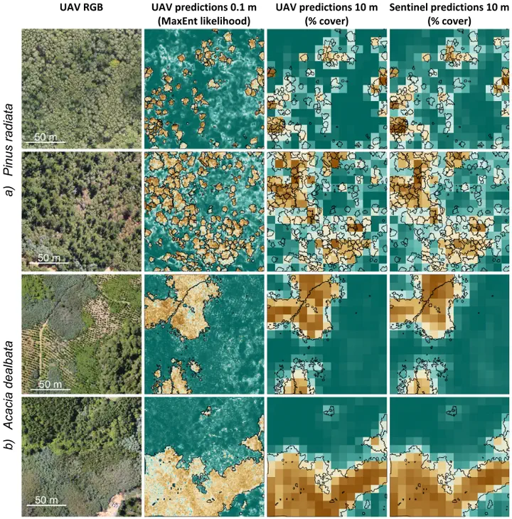
Invasive plant species can pose major threats to biodiversity, ecosystem functioning and services. Satellite based remote sensing has evolved as an important technology to spatially map the occurrence of invasive species in space and time. With the new era of the Sentinel missions, Synthetic Aperture Radar (SAR) and multispectral data are now freely available and repeatedly acquired on a high spatial and temporal resolution for the entire globe. However, the high potential of such sensors for automatic mapping procedures cannot be fully harnessed without sufficient and appropriate reference data for model calibration. Reference data are commonly acquired in field surveys, which however, are often relatively expensive and affected by sampling and observer bias. Moreover, a direct transferability to the remote sensing perspective and scale is difficult. Accordingly, we firstly assess the potential of Unmanned Aerial Vehicles (UAV) for semi-automatic reference data acquisition on species cover of three woody invasive species Pinus radiata, Ulex europaeus and Acacia dealbata occurring in Chile. Secondly, we test the upscaling of the estimated species cover to the spatial scale of Sentinel-1 and Sentinel-2. The proposed workflow includes the visual sampling of respective canopies in UAV orthomosaics and the subsequent spatial extrapolations using MaxEnt with spectral (RGB, Hyperspectral), textural (2D) and canopy structural (3D) predictors derived from UAV-based photogrammetry. These UAV-based maps are then used to train random forest models with multitemporal Sentinel-1 and Sentinel-2 data to map the invasive species cover on large spatial scales. Our results show that the semi-automatic UAV-based mapping of the three invasive species results in accurate predictions. Depending on the predictor combination, the correlation was 0.70, 0.77 and 0.90 for Pinus radiatia, Ulex europaeus, Acacia dealbata, respectively. Among the three species, we observed clear differences in the model performance between the tested photogrammetric predictors and their combinations (spectral, 2D texture or 3D structure). For scaling up the UAV-based estimates to the satellite-scale, the Sentinel-2 data (multispectral) were more important than Sentinel-1 data (SAR). An independent validation revealed that the R2 of the upscaling accounted for 0.78 or higher for all species and RMSE lower than 12%. Our results hence demonstrate that UAV-based reference data acquisitions are a promising alternative to traditional field surveys if the target species are directly identifiable in the UAV data.