RSC4Earth
RSC4Earth
Home
Mission
Team
Principle Investigators
Remote Sensing in Geo- and Ecosystem Research
Earth System Data Science
Remote Sensing Department at the UFZ
Geoinformatics and Remote Sensing
Support
Projects
Publications
Featured Publications
Recent Publications
Contact
Data
Invasive Species
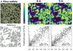
Convolutional Neural Networks Accurately Predict Cover Fractions of Plant Species and Communities in Unmanned Aerial Vehicle Imagery
Abstract Unmanned Aerial Vehicles ( UAV ) greatly extended our possibilities to acquire high resolution remote sensing data for …
Teja Kattenborn
,
Jana Eichel
,
Susan Wiser
,
Larry Burrows
,
Fabian E. Fassnacht
,
Sebastian Schmidtlein
Cite
DOI
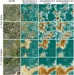
UAV Data as Alternative to Field Sampling to Map Woody Invasive Species Based on Combined Sentinel-1 and Sentinel-2 Data
Invasive plant species can pose major threats to biodiversity, ecosystem functioning and services. Satellite based remote sensing has …
Teja Kattenborn
,
Javier Lopatin
,
Michael Förster
,
Andreas Christian Braun
,
Fabian Ewald Fassnacht
Cite
DOI
Invasion by the Alien Tree Prunus Serotina Alters Ecosystem Functions in a Temperate Deciduous Forest
Alien invasive species can affect large areas, often with wide-ranging impacts on ecosystem structure, function, and services. Prunus …
Raf Aerts
,
Michael Ewald
,
Manuel Nicolas
,
Jérôme Piat
,
Sandra Skowronek
,
Jonathan Lenoir
,
Tarek Hattab
,
Carol X. Garzón-López
,
Hannes Feilhauer
,
Sebastian Schmidtlein
,
Duccio Rocchini
,
Guillaume Decocq
,
Ben Somers
,
Ruben Van De Kerchove
,
Karolien Denef
,
Olivier Honnay
Cite
DOI
Cite
×