RSC4Earth
RSC4Earth
Home
Mission
Team
Principle Investigators
Remote Sensing in Geo- and Ecosystem Research
Earth System Data Science
Remote Sensing Department at the UFZ
Geoinformatics and Remote Sensing
Support
Projects
Publications
Featured Publications
Recent Publications
Contact
Data
MAXENT
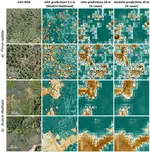
How Canopy Shadow Affects Invasive Plant Species Classification in High Spatial Resolution Remote Sensing
Abstract Plant invasions can result in serious threats for biodiversity and ecosystem functioning. Reliable maps at very-high spatial …
Javier Lopatin
,
Klara Dolos
,
Teja Kattenborn
,
Fabian E. Fassnacht
Cite
DOI
UAV Data as Alternative to Field Sampling to Map Woody Invasive Species Based on Combined Sentinel-1 and Sentinel-2 Data
Invasive plant species can pose major threats to biodiversity, ecosystem functioning and services. Satellite based remote sensing has …
Teja Kattenborn
,
Javier Lopatin
,
Michael Förster
,
Andreas Christian Braun
,
Fabian Ewald Fassnacht
Cite
DOI
Transferability of Species Distribution Models for the Detection of an Invasive Alien Bryophyte Using Imaging Spectroscopy Data
Remote sensing is a promising tool for detecting invasive alien plant species. Mapping and monitoring those species requires accurate …
Sandra Skowronek
,
Ruben Van De Kerchove
,
Bjorn Rombouts
,
Raf Aerts
,
Michael Ewald
,
Jens Warrie
,
Felix Schiefer
,
Carol Garzon-Lopez
,
Tarek Hattab
,
Olivier Honnay
,
Jonathan Lenoir
,
Duccio Rocchini
,
Sebastian Schmidtlein
,
Ben Somers
,
Hannes Feilhauer
Cite
DOI
Mapping an Invasive Bryophyte Species Using Hyperspectral Remote Sensing Data
Reliable distribution maps are crucial for the management of invasive plant species. An alternative to traditional field surveys is the …
Sandra Skowronek
,
Michael Ewald
,
Maike Isermann
,
Ruben Van De Kerchove
,
Jonathan Lenoir
,
Raf Aerts
,
Jens Warrie
,
Tarek Hattab
,
Olivier Honnay
,
Sebastian Schmidtlein
,
Duccio Rocchini
,
Ben Somers
,
Hannes Feilhauer
Cite
DOI
Performance of One-Class Classifiers for Invasive Species Mapping Using Airborne Imaging Spectroscopy
Most remote sensing approaches for mapping invasive plant species focus on species in a prominent phenological stage, such as during …
Sandra Skowronek
,
Gregory P. Asner
,
Hannes Feilhauer
Cite
DOI
Mapping Raised Bogs with an Iterative One-Class Classification Approach
Land use and land cover maps are one of the most commonly used remote sensing products. In many applications the user only requires a …
Benjamin Mack
,
Ribana Roscher
,
Stefanie Stenzel
,
Hannes Feilhauer
,
Sebastian Schmidtlein
,
Björn Waske
Cite
DOI
Remote Sensing of Scattered Natura 2000 Habitats Using a One-Class Classifier
Mapping of habitats with relevance for nature conservation involves the identification of patches of target habitats in a complex …
Stefanie Stenzel
,
Hannes Feilhauer
,
Benjamin Mack
,
Annekatrin Metz
,
Sebastian Schmidtlein
Cite
DOI
Cite
×