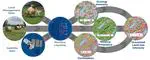
Deep Learning

ml4earth

Deliver novel AI techniques for earth observation satellite data for studies in earth and climate sciences

Mapping land-use intensity of grasslands in Germany with machine learning and Sentinel-2 time series

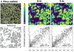
Information on grassland land-use intensity (LUI) is crucial for understanding trends and dynamics in biodiversity, ecosystem functioning, earth system science and environmental monitoring. LUI is a major driver for numerous environmental processes …

Spatially Autocorrelated Training and Validation Samples Inflate Performance Assessment of Convolutional Neural Networks

Deep learning and particularly Convolutional Neural Networks (CNN) in concert with remote sensing are becoming standard analytical tools in the geosciences. A series of studies has presented the seemingly outstanding performance of CNN for predictive …

DeepForest: Novel Deep Learning Models for Land Use and Land Cover Classification Using Multi-Temporal and -Modal Sentinel Data of the Amazon Basin

Land use and land cover (LULC) mapping is a powerful tool for monitoring large areas. For the Amazon rainforest, automated mapping is of critical importance, as land cover is changing rapidly due to forest degradation and deforestation. Several …

Convolutional Neural Networks Accurately Predict Cover Fractions of Plant Species and Communities in Unmanned Aerial Vehicle Imagery

Unmanned Aerial Vehicles (UAV) greatly extended our possibilities to acquire high resolution remote sensing data for assessing the spatial distribution of species composition and vegetation characteristics. Yet, current pixel- or texture-based …

Mapping Forest Tree Species in High Resolution UAV-Based RGB-Imagery by Means of Convolutional Neural Networks

The use of unmanned aerial vehicles (UAVs) in vegetation remote sensing allows a time-flexible and cost-effective acquisition of very high-resolution imagery. Still, current methods for the mapping of forest tree species do not exploit the …

Predicting Landscapes from Environmental Conditions Using Generative Networks

Landscapes are meaningful ecological units that strongly depend on the environmental conditions. Such dependencies between landscapes and the environment have been noted since the beginning of Earth sciences and cast into conceptual models describing …

Predicting landscapes as seen from space from environmental conditions

Satellite images are information rich snapshots of ecosystems and landscapes. In consequence, the features in the images strongly depend on the environmental conditions. Such dependency between climate and landscapes has been regarded since the …

Predicting Landscapes as Seen from Space from Environmental Conditions

Satellite images are information rich snapshots of ecosystems and landscapes. In consequence, the features in the images strongly depend on the environmental conditions. Such dependency between climate and landscapes has been regarded since the …