Combining Multiband Remote Sensing and Hierarchical Distance Sampling to Establish Drivers of Bird Abundance
Abstract
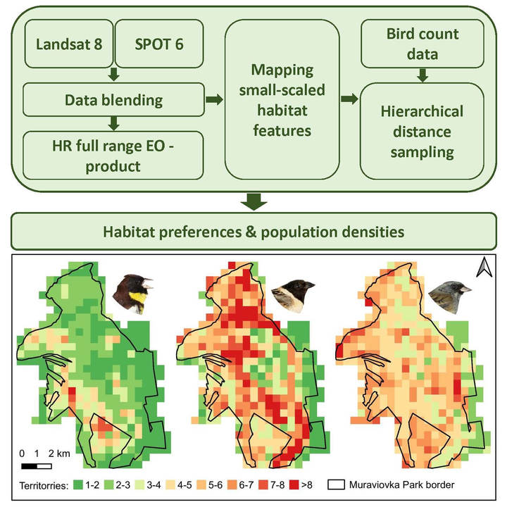
Information on habitat preferences is critical for the successful conservation of endangered species. For many species, especially those living in remote areas, we currently lack this information. Time and financial resources to analyze habitat use are limited. We aimed to develop a method to describe habitat preferences based on a combination of bird surveys with remotely sensed fine-scale land cover maps. We created a blended multiband remote sensing product from SPOT 6 and Landsat 8 data with a high spatial resolution. We surveyed populations of three bird species (Yellow-breasted Bunting Emberiza aureola, Ochre-rumped Bunting Emberiza yessoensis, and Black-faced Bunting Emberiza spodocephala) at a study site in the Russian Far East using hierarchical distance sampling, a survey method that allows to correct for varying detection probability. Combining the bird survey data and land cover variables from the remote sensing product allowed us to model population density as a function of environmental variables. We found that even small-scale land cover characteristics were predictable using remote sensing data with sufficient accuracy. The overall classification accuracy with pansharpened SPOT 6 data alone amounted to 71.3%. Higher accuracies were reached via the additional integration of SWIR bands (overall accuracy = 73.21%), especially for complex small-scale land cover types such as shrubby areas. This helped to reach a high accuracy in the habitat models. Abundances of the three studied bird species were closely linked to the proportion of wetland, willow shrubs, and habitat heterogeneity. Habitat requirements and population sizes of species of interest are valuable information for stakeholders and decision-makers to maximize the potential success of habitat management measures.