A Pan-African High-Resolution Drought Index Dataset
Abstract
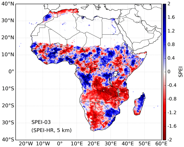
Droughts in Africa cause severe problems, such as crop failure, food shortages, famine, epidemics and even mass migration. To minimize the effects of drought on water and food security on Africa, a high-resolution drought dataset is essential to establish robust drought hazard probabilities and to assess drought vulnerability considering a multi- and cross-sectional perspective that includes crops, hydrological systems, rangeland and environmental systems. Such assessments are essential for policymakers, their advisors and other stakeholders to respond to the pressing humanitarian issues caused by these environmental hazards. In this study, a high spatial resolution Standardized Precipitation-Evapotranspiration Index (SPEI) drought dataset is presented to support these assessments. We compute historical SPEI data based on Climate Hazards group InfraRed Precipitation with Station data (CHIRPS) precipitation estimates and Global Land Evaporation Amsterdam Model (GLEAM) potential evaporation estimates. The high-resolution SPEI dataset (SPEI-HR) presented here spans from 1981 to 2016 (36 years) with 5 km spatial resolution over the whole of Africa. To facilitate the diagnosis of droughts of different durations, accumulation periods from 1 to 48 months are provided. The quality of the resulting dataset was compared with coarse-resolution SPEI based on Climatic Research Unit (CRU) Time Series (TS) datasets, Normalized Difference Vegetation Index (NDVI) calculated from the Global Inventory Monitoring and Modeling System (GIMMS) project and root zone soil moisture modelled by GLEAM. Agreement found between coarse-resolution SPEI from CRU TS (SPEI-CRU) and the developed SPEI-HR provides confidence in the estimation of temporal and spatial variability of droughts in Africa with SPEI-HR. In addition, agreement of SPEI-HR versus NDVI and root zone soil moisture – with an average correlation coefficient (R) of 0.54 and 0.77, respectively – further implies that SPEI-HR can provide valuable information for the study of drought-related processes and societal impacts at sub-basin and district scales in Africa. The dataset is archived in Centre for Environmental Data Analysis (CEDA) via the following link: https://doi.org/10.5285/bbdfd09a04304158b366777eba0d2aeb (Peng et al., 2019a).